Image creation software - List of Manufacturers, Suppliers, Companies and Products | IPROS

Image creation software Product List

1~3 item / All 3 items

Displayed results

Spherical Panorama Image Creation Software 【Sphere3】

~ Towards the Further Development of Fish Eye Culture ~ Sphere3 Ver.1

●Enhancement of Basic Functions - Improvement of joining accuracy by separating projection transformation processing and joining processing - Complete independence of joining function and viewing function - Expansion of application fields by outputting joining results in standard image format (jpeg) ●Enhancement of Viewing Functions - Enable viewing in stereoscopic projection - Enable viewing in full-screen mode - Enable addition of MP3 audio - Utilization of the latest web technologies (Flash Player 11.9)

  • Geological Survey Company
  • photograph
  • media
  • Image creation software

Added to bookmarks

Bookmarks list

Bookmark has been removed

Bookmarks list

You can't add any more bookmarks

By registering as a member, you can increase the number of bookmarks you can save and organize them with labels.

Free membership registration

3D Paint Rendering Piranesi

A presentation that impresses with a speedy finish.

Architectural perspective and presentation image creation software

  • Architectural CAD
  • others
  • Image creation software

Added to bookmarks

Bookmarks list

Bookmark has been removed

Bookmarks list

You can't add any more bookmarks

By registering as a member, you can increase the number of bookmarks you can save and organize them with labels.

Free membership registration

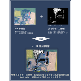
Tohoku University Technology: 2.1D: T22-281

Visualize 3D Land-Use Conditions in 2D!

In recent years, drone (UAV)-based surveying has increasingly used Structure from Motion (SfM) to derive three-dimensional information from multi-view images for assessing terrain and vegetation conditions. However, directly handling elevation data may require specialized processing environments and the capacity to manage large datasets, making it difficult to integrate such data into existing image-analysis workflows.  This invention provides a method for generating a surface composite image that utilizes acquired elevation information to facilitate an intuitive understanding of land-surface use and conditions. With this technology, height information derived from three-dimensional data can be represented as a widely compatible three-channel RGB image. As a result, the data can retain elevation information while remaining lightweight and easy to handle, enabling use in conventional image-processing environments and with a variety of freely available software tools.  In a comparative example of estate woodland extraction, the Dice coefficient was 0.64 when using orthophotos alone, whereas it increased to 0.80 when using the composite image, confirming improved extraction accuracy. These features make the technology promising as a practical means of seamlessly incorporating elevation information into existing image-based workflows, including vegetation assessment, visualization of land-surface use, and condition monitoring around disaster-affected areas and infrastructure.

  • others
  • Image creation software

Added to bookmarks

Bookmarks list

Bookmark has been removed

Bookmarks list

You can't add any more bookmarks

By registering as a member, you can increase the number of bookmarks you can save and organize them with labels.

Free membership registration